Sunny swell in White Rock!
sixlinewrasse - Wingfoiling |
Saturday December 07, 2024 1:03 PM |
| Spot | [Secret spot] |
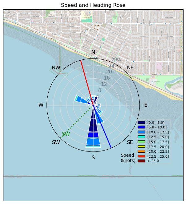
| Conditions | SW 14-16, Flat to swell |
| TOW | 1.5 hours |
| Toys | 5,4", 90 Lts. KT Hawaii Quatro Drifter Pro |
| 6M Ocean Rodeo Glide A | |
| 85cm HM Mast North Sonar | |
| 60 cm fuse North Sonar | |
| 1250 HA cm2 foil North Sonar | |
| S270 Stab North Sonar | |
| Details | Overpowered only 1/2hr into the session, but keep it going, as days are too short for a re-rig. Stopped to dis-entangle a sharp beaked Murre from fishing line around it's wing, neck and foot as it tried to peck through my mitt. The tangle was so bad I started to wonder if it was possible to save it, but finally freed it in good condition. A dozen kites in the air once the tide went out and the sun showed up. [from Session Log on Saturday December 07, 2024] |
Speed (3s average)
| Speed | knots | km/h |
|---|---|---|
| Avg overall | 6.8 | 12.7 |
| Avg in motion | 12.2 | 22.6 |
| Max | 22.8 | 42.3 |
| Max 100m | 13.8 | 25.5 |
| Max 250m | 12.6 | 23.3 |
| Max 500m | 12.2 | 22.6 |
| Max 2s | 22.1 | 40.9 |
| Max 10s | 15.0 | 27.8 |
| Max Alpha (500/50m) | 7.9 | 14.6 |
| Avg Foiling | 13.1 | 24.4 |
Times and Duration
| Start | Sat Dec 07, 1:03 PM |
| End | Sat Dec 07, 2:43 PM |
| Duration | 01:39:27 |
| In motion | 00:55:46 |
| Paused (< 3 km/h) | 00:18:52 |
| Foiling | 00:47:23 |
| Not Foiling (< 8 km/h) | 00:27:15 |
| Longest Foiling Segment | 00:04:43 (1.9 km) |
| Last Calculated | Sat Dec 07, 8:28 PM |
Track Information
| Distance | 21.0 km |
| # Trackpoints | 5886 |
| Avg Trackpoint distance | 3.6 m |
| Number of Turns | 79 |
| Foiling Turns (> 8 km/h) | 58 |
| Foiling Turn Percentage | 73% |


Category: Wingfoiling
3 weeks ago

Created 3 weeks ago
sixlinewrasse |
Please register/login to download this track.
This track was downloaded 0 time(s). |
| 19 A C-lover Christmas |
| 43 Eve Slide |
| 38 241224 Ross Bay |
| 29 RB - Xmas Eve Excellence |
| 38 Last 2024 Victoria Session -- Happy Holidays!! |
Please wait while loading suggestions..
Please wait while loading suggestions..
You must login to post comments.