Twilight&Tweezer
UnusuallyLargeRobin - Wingfoiling |
Tuesday March 19, 2024 6:36 PM |
| Spot | Ross Bay |
| Conditions | SW 7-13, flat |
| TOW | 1.0 hours |
| Toys | 187 lb / 85 kg Me Carbon-based Lifeform |
| PNG 1150 (1713cm2) Axis Front Foil | |
| Crazyshort (58.5cm) Axis Red Fuselage | |
| 425 P Axis Rear Foil/Stab | |
| 90cm Axis Alu Mast | |
| 5.5 Duotone Unit | |
| 5'8 128lt Indiana Wing Foil Carbon | |
| Details | Got a text from Tweezer just as I was looking at the RB Cam and the wind looked like it may be doable! Threw everything in the car and tore down there for a 6:45pm start. A gorgeous blue sky evening, quite warm, no gloves required. DrMark was just arriving too and first out, quickly followed by Tweezer and myself. Extremely light on the inside and really just a band of pumpable flyable wind from point distance to the kelp line. My big gear made all the difference in the world for me and it wasn't too hard to keep flying at all times. Tweezer and I made our way up to the point where the best wind was wrapping around. We stayed in the short wind band and milked it till dusky twilight. [from Session Log on Tuesday March 19, 2024] |
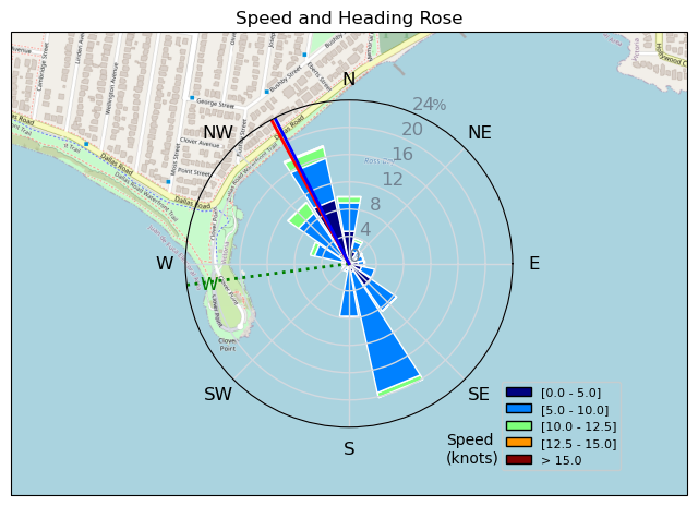
Speed (3s average)
| Speed | knots | km/h |
|---|---|---|
| Avg overall | 6.4 | 11.9 |
| Avg in motion | 7.5 | 14.0 |
| Max | 13.0 | 24.1 |
| Max 100m | 11.7 | 21.7 |
| Max 250m | 10.4 | 19.3 |
| Max 500m | 9.6 | 17.8 |
| Max 2s | 13.0 | 24.0 |
| Max 10s | 12.5 | 23.1 |
| Max Alpha (500/50m) | 9.6 | 17.7 |
| Avg Foiling | 8.6 | 15.9 |
Times and Duration
| Start | Tue Mar 19, 6:36 PM |
| End | Tue Mar 19, 7:35 PM |
| Duration | 00:58:53 |
| In motion | 00:50:04 |
| Paused (< 3 km/h) | 00:07:38 |
| Foiling | 00:39:43 |
| Not Foiling (< 8 km/h) | 00:17:59 |
| Longest Foiling Segment | 00:08:35 (2.2 km) |
| Last Calculated | Tue Mar 19, 10:29 PM |
Track Information
| Distance | 11.7 km |
| # Trackpoints | 3511 |
| Avg Trackpoint distance | 3.3 m |
| Number of Turns | 67 |
| Foiling Turns (> 8 km/h) | 49 |
| Foiling Turn Percentage | 73% |


Category: Wingfoiling
10 months ago

Created 10 months ago
UnusuallyLargeRobin |
Please register/login to download this track.
This track was downloaded 0 time(s). |
| 60 Falck’n Foot Switches |
| 60 250112 Cattle Point |
| 60 Speedy (for me) wave riding |
| 55 CP - TunaCan Flyby |
| 85 Rippin the right radii |
Please wait while loading suggestions..
Please wait while loading suggestions..
You must login to post comments.