JustAsAdvertised
UnusuallyLargeRobin - Wingfoiling |
Saturday April 27, 2024 8:30 AM |
| Spot | Ross Bay |
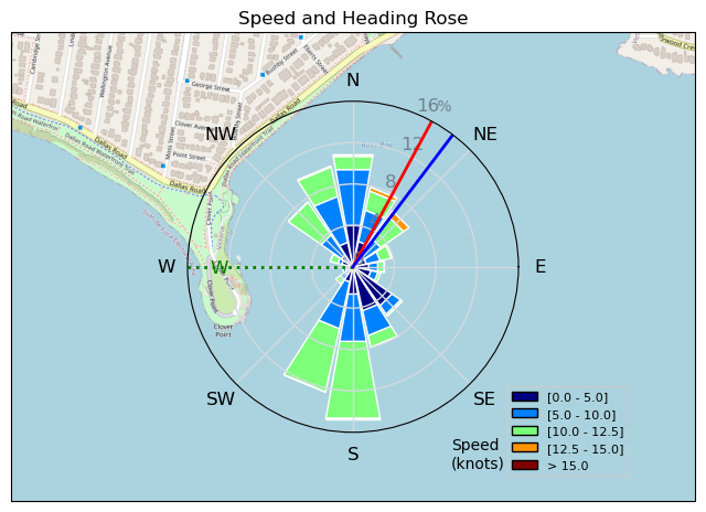
| Conditions | W 12-20, 1-2' |
| TOW | 1.5 hours |
| Toys | 187 lb / 85 kg Me Carbon-based Lifeform |
| PNG 1150 (1713cm2) Axis Front Foil | |
| 365/55 Skinny Axis Rear Foil/Stab | |
| HPS 1050 (1460cm2) Axis Foil | |
| 425 P Axis Rear Foil/Stab | |
| 90cm Axis Alu Mast | |
| 5.5 Duotone Unit | |
| 5'8 128lt Indiana Wing Foil Carbon | |
| 75 lt Fanatic Sky Wing 5'0 | |
| Details | Popped out of bed early, checked the wind and RB cam, packed up and texted Tweezer "heading to RB". Looked pretty light when i arrived with only Docker out and Bobson rigging up some foreign looking craft (lost his wing gear?) Rigged my ultra light wind kit. A short schlog on the inside, then got to the wind and it was a lot windier than i thought with plenty of dark water and white caps west of of the point and making their way towards the bay. After a few reaches it was overpowered and twitchy so went in to rig down. So much better on the smaller stuff! Tweezer and i played around the point and buzzed around Highrocker for a bit. Did a stint in some pelting rain, after a while spidey senses told me to pack it in. Got really light 5 minutes later just as advertised. [from Session Log on Saturday April 27, 2024] |
Speed (3s average)
| Speed | knots | km/h |
|---|---|---|
| Avg overall | 7.0 | 13.0 |
| Avg in motion | 8.8 | 16.3 |
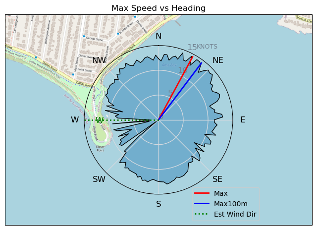
| Max | 14.5 | 26.8 |
| Max 100m | 13.6 | 25.2 |
| Max 250m | 11.9 | 22.1 |
| Max 500m | 11.5 | 21.3 |
| Max 2s | 14.4 | 26.7 |
| Max 10s | 14.0 | 26.0 |
| Max Alpha (500/50m) | 10.8 | 19.9 |
| Avg Foiling | 9.7 | 18.0 |
Times and Duration
| Start | Sat Apr 27, 8:30 AM |
| End | Sat Apr 27, 10:08 AM |
| Duration | 01:37:57 |
| In motion | 01:18:19 |
| Paused (< 3 km/h) | 00:14:45 |
| Foiling | 01:06:43 |
| Not Foiling (< 8 km/h) | 00:26:21 |
| Longest Foiling Segment | 00:13:44 (4.2 km) |
| Last Calculated | Sat Apr 27, 11:08 PM |
Track Information
| Distance | 21.3 km |
| # Trackpoints | 5874 |
| Avg Trackpoint distance | 3.6 m |
| Number of Turns | 100 |
| Foiling Turns (> 8 km/h) | 69 |
| Foiling Turn Percentage | 69% |


Category: Wingfoiling
9 months ago

Created 9 months ago
UnusuallyLargeRobin |
Please register/login to download this track.
This track was downloaded 0 time(s). |
| 17 BWD got me addicted |
| 65 Falck’n Foot Switches |
| 64 250112 Cattle Point |
| 64 Speedy (for me) wave riding |
| 59 CP - TunaCan Flyby |
Please wait while loading suggestions..
Please wait while loading suggestions..
You must login to post comments.